If you hadn’t heard, heavy rains have caused serious flooding along the Llano river and the Texas hill country.
The Farm to Market 2900 bridge in Kingsland over Lake LBJ (just before the Llano and Colorado rivers meet) has collapsed:
Authorities have evacuated anyone within a quarter-mile of the river, including large portions of Marble Falls. The Lower Colorado River Authority opened the Mansfield and Tom Miller dams at noon.
Nor is the hazard limited to the river:
Williamson County conducted two water rescues because of flooding Tuesday morning. One was a vehicle in high water off CR 251 in Andice, and both people were transported to a local hospital.
The second was a school bus off CR 177 in Leander. The driver and one student on broad were rescued without injuries.
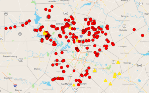
I would tell you to check the low water crossing map for the Austin area, but there’s no need: Every low water crossing in Austin is closed, flooded or on caution right now:
The cliched phrase of choice is there for a reason:

Pay attention to the evacuation notices, and pack your bugout bag and be ready to go if you’re in low-lying areas or anywhere near the river.
As for myself, I’m fine. The last time I looked at a topology map I was some 85′ higher than the Mansfield Dam spillway, so I’m safe unless we get a flood of Biblical proportion.
Tags: Austin, flooding, LCRA, Texas, video, weather, Williamson County
That’s “topographic” map. Topology is a branch of mathematics.